Dear Customers! Our store will be closed from the 15.04-20.04.24
Your partner for aviation supplies since 1994
Constantly growing assortment
Hotline + 49(0)30 864746-0
Cookie preferences
This website uses cookies, which are necessary for the technical operation of the website and are always set. Other cookies, which increase the comfort when using this website, are used for direct advertising or to facilitate interaction with other websites and social networks, are only set with your consent.
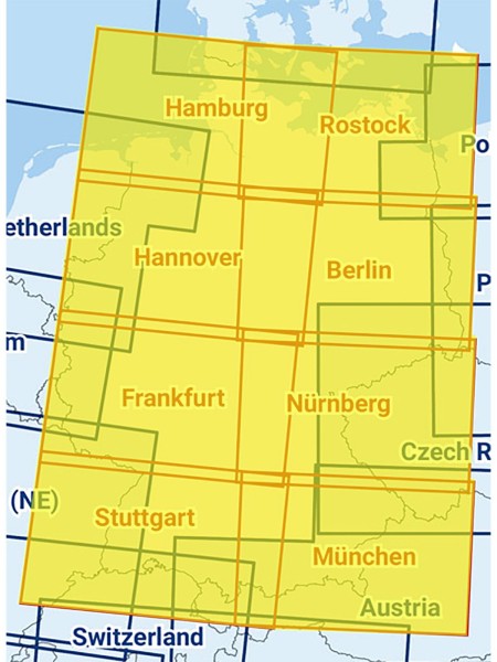
This is the official ICAO chart for VFR flights in Germany. It contains important information about topography and air traffic control like streets, railways, rivers, woods, urbanisation, elevation points, obstacles, airfields, air space and lots more. On the backsde you will find legend and more helpful information.
According to the harmonization of European ICAO Charts the colour for the airspace classes C, D, and E has been changed into blue. Further on the identifier MSL (Mean Sea Level) has been omitted, and the identifier GND is replaced by AGL (Above Ground Level).
In total the ICAO charts are seperated in 8 sheets - Hamburg, Rostock, Hannover, Berlin, Frankfurt, Nuremberg, Stuttgart and Munich.
Format per chart sheet: 83,5 x 61 cm Scale: 1:500.000
This chart is: ICAO Chart Germany (all 8 sheets) composited, laminated
Related links to "Complete ICAO Chart Germany (8 Sheets composited, laminated)"
Funktionale Cookies sind für die Funktionalität des Webshops unbedingt erforderlich. Diese Cookies ordnen Ihrem Browser eine eindeutige zufällige ID zu damit Ihr ungehindertes Einkaufserlebnis über mehrere Seitenaufrufe hinweg gewährleistet werden kann.
Session:
Das Session Cookie speichert Ihre Einkaufsdaten über mehrere Seitenaufrufe hinweg und ist somit unerlässlich für Ihr persönliches Einkaufserlebnis.
Merkzettel:
Das Cookie ermöglicht es einen Merkzettel sitzungsübergreifend dem Benutzer zur Verfügung zu stellen. Damit bleibt der Merkzettel auch über mehrere Browsersitzungen hinweg bestehen.
Gerätezuordnung:
Die Gerätezuordnung hilft dem Shop dabei für die aktuell aktive Displaygröße die bestmögliche Darstellung zu gewährleisten.
CSRF-Token:
Das CSRF-Token Cookie trägt zu Ihrer Sicherheit bei. Es verstärkt die Absicherung bei Formularen gegen unerwünschte Hackangriffe.
Login Token:
Der Login Token dient zur sitzungsübergreifenden Erkennung von Benutzern. Das Cookie enthält keine persönlichen Daten, ermöglicht jedoch eine Personalisierung über mehrere Browsersitzungen hinweg.
Cache Ausnahme:
Das Cache Ausnahme Cookie ermöglicht es Benutzern individuelle Inhalte unabhängig vom Cachespeicher auszulesen.
Cookies Aktiv Prüfung:
Das Cookie wird von der Webseite genutzt um herauszufinden, ob Cookies vom Browser des Seitennutzers zugelassen werden.
Cookie Einstellungen:
Das Cookie wird verwendet um die Cookie Einstellungen des Seitenbenutzers über mehrere Browsersitzungen zu speichern.
Herkunftsinformationen:
Das Cookie speichert die Herkunftsseite und die zuerst besuchte Seite des Benutzers für eine weitere Verwendung.
Aktivierte Cookies:
Speichert welche Cookies bereits vom Benutzer zum ersten Mal akzeptiert wurden.
PayPal-Zahlungen
Tracking
Tracking Cookies helfen dem Shopbetreiber Informationen über das Verhalten von Nutzern auf ihrer Webseite zu sammeln und auszuwerten.
Google Analytics / AdWords
Google Tag Manager
Partnerprogramm
Google Analytics:
Google Analytics wird zur der Datenverkehranalyse der Webseite eingesetzt. Dabei können Statistiken über Webseitenaktivitäten erstellt und ausgelesen werden.
This website uses cookies to ensure you get the best experience on our website.
More information


 - laminated, unfolded, 1:500,000 (2 parts)")


")


 - 2 In")
 5/6")

-Guide - Complete Set Planes")
")