Dear Customers! Our store will be closed from the 15.04-20.04.24
Your partner for aviation supplies since 1994
Constantly growing assortment
Hotline + 49(0)30 864746-0
Cookie preferences
This website uses cookies, which are necessary for the technical operation of the website and are always set. Other cookies, which increase the comfort when using this website, are used for direct advertising or to facilitate interaction with other websites and social networks, are only set with your consent.
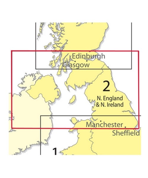
United Kingdom ICAO Chart - Norhtern England & Northern Ireland - 1:500,000, paper, folded
Produced as part of the CAA chart series, the Southern England 1:500 000 chart serves the requirements of VFR in-flight navigation for low speed, short or medium range operations at low and intermediate altitudes. Airspace information up to FL195 and obstacles above 300ft AGL are depicted and meets the ICAO standards and recommended practices as defined in ICAO Annex 4. In addition to aeronautical information, the charts provide hydrographic, topographic, cultural and other visual features compatible with legibility at the scale of the chart this information is supplied by GB Ordnance Survey with terrain contours at intervals above 500ft AMSL depicted.
Area: Northern England and Northern Ireland Chart type: VFR Scale: 1:500,000
Related links to "United Kingdom ICAO Chart - Norhtern England & Northern Ireland - 1:500,000, paper, folded"
Funktionale Cookies sind für die Funktionalität des Webshops unbedingt erforderlich. Diese Cookies ordnen Ihrem Browser eine eindeutige zufällige ID zu damit Ihr ungehindertes Einkaufserlebnis über mehrere Seitenaufrufe hinweg gewährleistet werden kann.
Session:
Das Session Cookie speichert Ihre Einkaufsdaten über mehrere Seitenaufrufe hinweg und ist somit unerlässlich für Ihr persönliches Einkaufserlebnis.
Merkzettel:
Das Cookie ermöglicht es einen Merkzettel sitzungsübergreifend dem Benutzer zur Verfügung zu stellen. Damit bleibt der Merkzettel auch über mehrere Browsersitzungen hinweg bestehen.
Gerätezuordnung:
Die Gerätezuordnung hilft dem Shop dabei für die aktuell aktive Displaygröße die bestmögliche Darstellung zu gewährleisten.
CSRF-Token:
Das CSRF-Token Cookie trägt zu Ihrer Sicherheit bei. Es verstärkt die Absicherung bei Formularen gegen unerwünschte Hackangriffe.
Login Token:
Der Login Token dient zur sitzungsübergreifenden Erkennung von Benutzern. Das Cookie enthält keine persönlichen Daten, ermöglicht jedoch eine Personalisierung über mehrere Browsersitzungen hinweg.
Cache Ausnahme:
Das Cache Ausnahme Cookie ermöglicht es Benutzern individuelle Inhalte unabhängig vom Cachespeicher auszulesen.
Cookies Aktiv Prüfung:
Das Cookie wird von der Webseite genutzt um herauszufinden, ob Cookies vom Browser des Seitennutzers zugelassen werden.
Cookie Einstellungen:
Das Cookie wird verwendet um die Cookie Einstellungen des Seitenbenutzers über mehrere Browsersitzungen zu speichern.
Herkunftsinformationen:
Das Cookie speichert die Herkunftsseite und die zuerst besuchte Seite des Benutzers für eine weitere Verwendung.
Aktivierte Cookies:
Speichert welche Cookies bereits vom Benutzer zum ersten Mal akzeptiert wurden.
PayPal-Zahlungen
Tracking
Tracking Cookies helfen dem Shopbetreiber Informationen über das Verhalten von Nutzern auf ihrer Webseite zu sammeln und auszuwerten.
Google Analytics / AdWords
Google Tag Manager
Partnerprogramm
Google Analytics:
Google Analytics wird zur der Datenverkehranalyse der Webseite eingesetzt. Dabei können Statistiken über Webseitenaktivitäten erstellt und ausgelesen werden.
This website uses cookies to ensure you get the best experience on our website.
More information